![](/images/other/stat-length.png)
![Randonnée Marche Le Bono - Du Bono à la Chapelle de Saint-Avoye - Photo](https://media.geolcdn.com/t/1900/400/ext.pjpeg?maxdim=2&url=https%3A%2F%2Fservices.sitytrail.com%2FGeolivesWS%2FDownloadMedia.ashx%3FTrailID%3D455675%26Media%3Dfix__20150807180035.jpg)
Du Bono à la Chapelle de Saint-Avoye
jeanclaude12
Utilisateur
![Longueur](/images/other/stat-length.png)
![Altitude max](https://static1.geolcdn.com/siteimages/upload/files/1508320355ic_sort_altitude_max_24dp.png)
![Dénivelé positif](https://static1.geolcdn.com/siteimages/upload/files/1508320355ic_sort_den_pos_24dp.png)
![Km-Effort](/images/other/stat-length.png)
![Altitude min](https://static1.geolcdn.com/siteimages/upload/files/1508320355ic_sort_altitude_min_24dp.png)
![Dénivelé négatif](https://static1.geolcdn.com/siteimages/upload/files/1508320355ic_sort_den_neg_24dp.png)
![Boucle](https://static1.geolcdn.com/siteimages/upload/files/16400158638029165_repeat_loop_refresh_sync_direction_icon.png)
![Marche](https://static1.geolcdn.com/sitytour/trail-icons/101.png)
2h47
Difficulté : Facile
![Scannez ce code QR pour ouvrir la randonnée dans l'application SityTrail](https://capi.geolives.com/qq0zvz2zws4bq2lad0pu/sitytour/trails/455675/qr.png?size=200)
Application GPS de randonnée GRATUITE
À propos
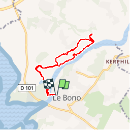
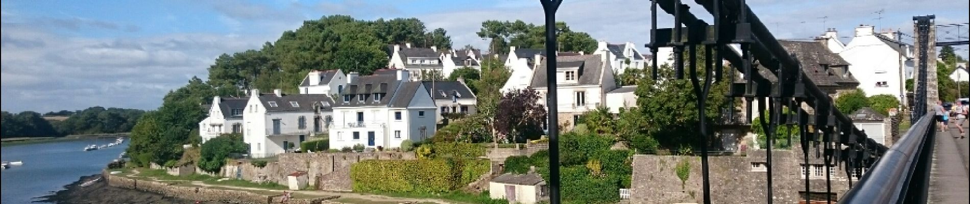
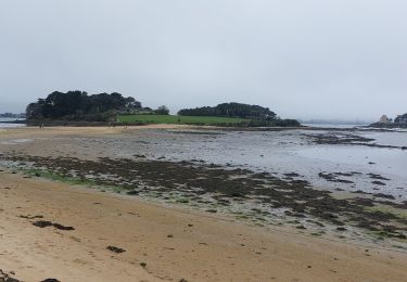
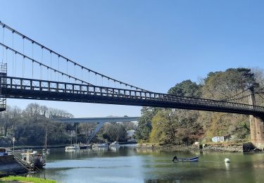
Randonnée Marche de 8 km à découvrir à Bretagne, Morbihan, Le Bono. Cette randonnée est proposée par jeanclaude12.
Description
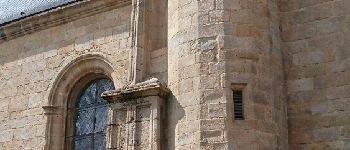
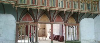
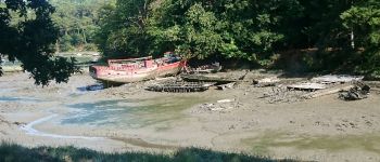
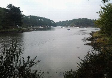
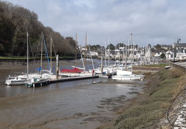
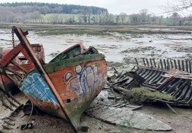
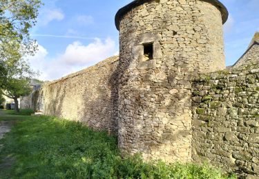
Le parcours longe la rivière du Sal par un sentier côtier bordé de chênes têtards jusqu'à la Chapelle Renaissance du XI ème siècle, chapelle seigneuriale construite par le comte de Lestrelin connue pour son jugé, ses extraits sculptés et. ses couvre-sablières. Le parcours à l'ombre des chênes-têtards fait découvrir un cimetière de bateaux témoignant de l'activité des anciens marins ostréiculteurs du lieu.
Localisation
Commentaires
Randonnées à proximité
![Randonnée Marche Pluneret - st Avoye - Photo](https://media.geolcdn.com/t/375/260/ext.jpg?maxdim=2&url=https%3A%2F%2Fservices.sitytrail.com%2FGeolivesWS%2FDownloadMedia.ashx%3FTrailID%3D159588%26Media%3D20121024110349.jpeg)
![Marche Marche](https://static1.geolcdn.com/sitytour/trail-icons/101.png)
![Randonnée Marche Baden - PR_56_Baden_DA_04_Circuit4a_Pointe-De-Locmiquel_20240317 - Photo](https://media.geolcdn.com/t/375/260/28b1849b-0798-4b99-85e4-eaa3b59fa830.jpg&format=jpg&maxdim=2)
![Marche Marche](https://static1.geolcdn.com/sitytour/trail-icons/101.png)
Marche
![](/images/other/stat-length.png)
![](https://static1.geolcdn.com/siteimages/upload/files/16400158638029165_repeat_loop_refresh_sync_direction_icon.png)
![Randonnée Marche Pluneret - PR_56_Pluneret_EA_06_Circuit1b_Tro-Ar-Vourch_20240227 - Photo](https://media.geolcdn.com/t/375/260/5d6bdb50-6a7c-4d72-8e80-1296b3e69841.jpg&format=jpg&maxdim=2)
![Marche Marche](https://static1.geolcdn.com/sitytour/trail-icons/101.png)
Marche
![](/images/other/stat-length.png)
![](https://static1.geolcdn.com/siteimages/upload/files/16400158638029165_repeat_loop_refresh_sync_direction_icon.png)
![Randonnée Marche Plougoumelen - PR_56_Plougoumelen_CA_03_Circuit4a_Du-Boterff_20231011 - Photo](https://media.geolcdn.com/t/375/260/d3c418c5-7ec8-4dd5-81ed-a4f492fa39d3.jpg&format=jpg&maxdim=2)
![Marche Marche](https://static1.geolcdn.com/sitytour/trail-icons/101.png)
Marche
![](/images/other/stat-length.png)
![](https://static1.geolcdn.com/siteimages/upload/files/16400158638029165_repeat_loop_refresh_sync_direction_icon.png)
![Randonnée Marche Auray - port saint goustan,port bono - Photo](https://media.geolcdn.com/t/375/260/12116764-6d8c-4e87-8742-90bc6f2c0827.jpg&format=jpg&maxdim=2)
![Marche Marche](https://static1.geolcdn.com/sitytour/trail-icons/101.png)
Marche
![](/images/other/stat-length.png)
![](https://static1.geolcdn.com/siteimages/upload/files/16400158638029165_repeat_loop_refresh_sync_direction_icon.png)
![Randonnée Marche Pluneret - PR_56_Pluneret_AB_04_Circuit1b_Les-Deux-Rivieres_20230221 - Photo](https://media.geolcdn.com/t/375/260/93c0f218-ebed-477b-bd47-1f60865f1de6.jpg&format=jpg&maxdim=2)
![Marche Marche](https://static1.geolcdn.com/sitytour/trail-icons/101.png)
Marche
![](/images/other/stat-length.png)
![](https://static1.geolcdn.com/siteimages/upload/files/16400158638029165_repeat_loop_refresh_sync_direction_icon.png)
![Randonnée Marche Pluneret - PR_56_Pluneret_CA_03_Circuit1b_Anse-Du-Teno_20221120 - Photo](https://media.geolcdn.com/t/375/260/bd8d16df-d91c-4abb-9d2b-d13070c275ca.jpg&format=jpg&maxdim=2)
![Marche Marche](https://static1.geolcdn.com/sitytour/trail-icons/101.png)
Marche
![](/images/other/stat-length.png)
![](https://static1.geolcdn.com/siteimages/upload/files/16400158638029165_repeat_loop_refresh_sync_direction_icon.png)
![Randonnée Marche Le Bono - 56-Bono-9km - Photo](https://media.geolcdn.com/t/375/260/d693d4bc-73fd-4dca-9046-40ecea606032.jpg&format=jpg&maxdim=2)
![Marche Marche](https://static1.geolcdn.com/sitytour/trail-icons/101.png)
![Randonnée Marche Le Bono - PR_56_Bono_AA_01_Circuit1b_La-Riviere-Du-Bono_20220324 - Photo](https://media.geolcdn.com/t/375/260/f25778c3-1356-4ddd-8e62-718d2a61fdc0.jpg&format=jpg&maxdim=2)
![Marche Marche](https://static1.geolcdn.com/sitytour/trail-icons/101.png)
Marche
![](/images/other/stat-length.png)
![](https://static1.geolcdn.com/siteimages/upload/files/16400158638029165_repeat_loop_refresh_sync_direction_icon.png)
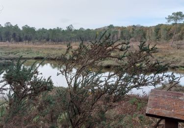
Agréable promenade sur ce sentier bien ombragé. Bien agréable sous ces fortes chaleurs.